
Update at 3:30pm on September 28th, 2022
Hurricane Ian makes landfall near Cayo Costa, Florida as a Category 4 hurricane, per National Hurricane Center.
Update at 2:30pm on September 28th, 2022
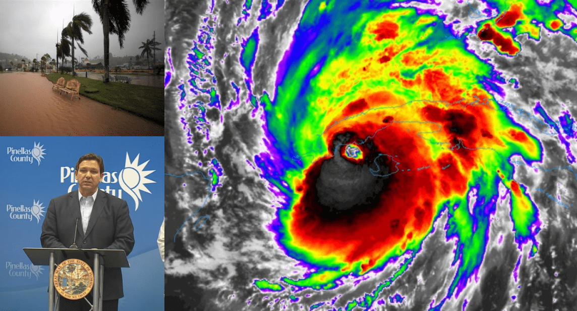
Governor DeSantis addressed the residents of Florida as to the current status of ongoing hurricane response in the state.
As the eyewall of Hurricane Ian approached Sanibel Island around 12pm, according to the National Hurricane Center, with winds approaching 155mph. This is considered near-Category 5 stength.
Over 483,00 residences and businesses have reported losing power, according to the poweroutage.us.
According to reporting from Weather.com, cars and boats could be seen floating down the city of Fort Meyers, with trees bent in half.
WATCH: Fort Myers Beach Weather Camera Captures EXTREME Footage
WATCH: Parking Garages Flood Pelican Bay in Naples, FL
Update at 6:30pm on September 27th, 2022
Hurricane Ian gained significant strength as it traveled northward in Gulf waters on Tuesday afternoon. Experts predict the storm will continue to strengthen into Tuesday evening and the early hours of Wednesday morning. It is expected to intensify into a Category 4 hurricane. An estimated 2.5 million people are under evacuation orders at this time. The path of the storm has shifted south over the course of the day, putting Ft. Myers, Florida in the crosshairs of Hurricane Ian.
Published 10am on September 27th, 2022
The state of Florida is bracing for the impact of Hurricane Ian currently barreling toward the western coastline.
Governor Ron DeSantis addressed Floridians on Monday, updating them on existing preparations and laying expectations for the coming week.
The Florida National Guard activated five thousand guardsmen early this week. Two thousand guardsmen from neighboring states have also been activated.
DeSantis said all 67 counties in Florida may be directly or indirectly affected, due to evacuations and supply chain strains. Walmart and Publix have been alerted to the heightened need for supplies, including water.
All major utility companies are in contact with the state of Florida. Over 25,000 linemen are stationed and ready to go, per DeSantis.
The governor warned all citizens of the state to “…be prepared to lose power.”
Hundreds of pumps and generators have been stationed in the Tampa Bay area.
Watch full comments by the governor here:
Hurricane Ian hit Cuba on Tuesday morning as a Category 3 storm. Sustained wind speeds of 125-mph were recorded by weather trackers at AccuWeather.
The projected path of Ian will lead directly to Tampa Bay and St. Petersburg area.
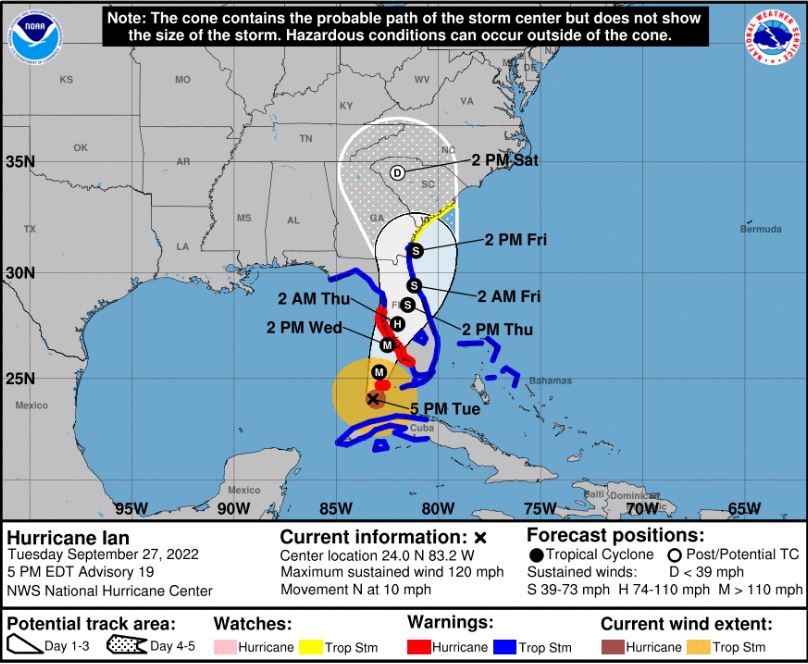
Heavy rainfall will start and increase in the Florida Keys on Tuesday and continue northward.
Photo credits: hellenicdailynewsny.com, ABC7NY, Newsweek, WDBO.